How to Bulk Geotag Photos: Add GPS to Hundreds of Images at Once
Most geotagging jobs are not single photos. A wedding shoot produces hundreds of frames at one venue. A construction progress report documents one site across fifty images. A property listing carries twenty photos of one address. In every one of these cases the photos share a single correct location — which means the work should be done once, not once per file.
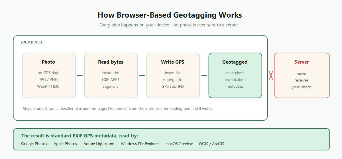
That is what batch geotagging is for: set the coordinates one time and write them into every file in the group. Done right, tagging 300 photos takes barely longer than tagging 3.
When Bulk Geotagging Makes Sense
- Real estate shoots: every photo of a listing belongs to one address. Batch-tagging the full set keeps MLS records consistent — our real estate guide covers the details.
- Business photo libraries: photos destined for a Google Business Profile should carry the business's coordinates. Tag each location's set in one pass — see the Google Business Profile guide.
- Events: weddings, conferences, and festivals happen at one venue. One batch, one pin.
- Field and site documentation: inspections, surveys, and construction progress photos need consistent, verifiable coordinates for reporting.
- Travel archive repair: photos that lost GPS in transit — WhatsApp transfers, social media downloads, old camera imports — can be restored city by city.
- Scanned photo collections: digitized prints have no metadata at all. Batch-tagging by place (the family home, a holiday destination) makes decades of scans mappable.
Bulk Geotagging in the Browser, Step by Step
FreeGeoTagger processes batches entirely on your device — no uploads, no account, no per-file fees. The workflow:
Step 1: Group photos by location
Before opening any tool, sort your photos into one folder per location. Capture time is usually the quickest sorting key — photos from the same place cluster together chronologically. This preparation step is what makes the rest of the process fast: each folder becomes one batch with one pin.
Step 2: Upload a batch
Drag an entire folder's photos into the upload zone, or use multi-select in the file picker (Ctrl/Cmd-click on desktop; long-press then tap on mobile). JPG, PNG, WebP, and HEIC files are all supported, and HEIC converts automatically. The files load instantly because nothing is transferred over the network.
Step 3: Set one location for the batch
Zoom into the map and click the exact spot, search the address, or paste coordinates from Google Maps. The location applies to every uploaded photo simultaneously. For precision work, zoom to street level before pinning — a click at high zoom is accurate to a few meters.
Step 4: Download as ZIP
One click downloads the entire geotagged batch as a ZIP archive, with each file's EXIF GPS fields written and pixel data untouched. Extract, spot-check a couple of files with the GPS Finder, and move on to the next folder.
Repeating this loop, a multi-location archive — say, a two-week trip across five cities — takes a few minutes total: five folders, five pins, five ZIPs.
Browser Batch vs Desktop Software vs Command Line
There are three realistic approaches to bulk geotagging, and each has a legitimate use case:
- Browser-based (FreeGeoTagger): zero install, free batch support, complete privacy since files never leave the device. For advanced multi-location queues and CSV mapping, use our dedicated Batch Geotag Photos tool.
- Desktop software (Lightroom, GeoSetter): worthwhile when you need track-log matching — syncing photo timestamps against a GPS track recorded while shooting, so each photo gets its own position along a route. Overkill for single-location batches, and batch features are often paywalled.
- Command line (ExifTool): unbeatable for automation and very large archives — one command can tag thousands of files or apply a track log. The cost is a learning curve and no visual map to verify against. Our free geotagging tools comparison weighs all three in detail.
Batch Geotagging Pitfalls to Avoid
- Mixed-location batches: the classic error is uploading a whole camera roll and stamping everything with one pin. Sort first; photos from different places belong in different batches.
- Tagging the copies you're about to publish: location data on publicly shared photos can be a privacy leak. Tag your archive originals, and strip GPS from public copies — our GPS removal guide explains when and how.
- Skipping verification: after any bulk operation, check two or three random outputs with a GPS reader. Thirty seconds of spot-checking catches a wrong pin before it propagates into hundreds of files.
- Overwriting good data: if some photos in a folder already carry correct native GPS, exclude them from the batch — rewriting their coordinates with a map pin replaces precise data with approximate data.
Why Local Processing Matters at Batch Scale
For a single photo, uploading to a cloud geotagging service is a minor privacy trade-off. For a batch, it multiplies: three hundred photos of your home, your job site, or your clients' properties sitting on someone else's server is a very different exposure. Browser-local processing sidesteps the issue entirely — the batch never exists anywhere except your own device — and it is also simply faster, since there is no upload or download time for the images themselves.
Conclusion
Bulk geotagging turns a tedious per-file chore into a few minutes of folder sorting and map clicks: group photos by place, upload each group to FreeGeoTagger, pin the location once, and download the finished ZIP. No installs, no accounts, no cost, and no photos leaving your device — whether the batch is a listing's twenty photos or a summer's worth of travel.
Frequently asked questions
How do I geotag multiple photos at once?
Select all the photos that share a location, set that location once on the map or by address, then download them together as a ZIP. Each file gets the same GPS coordinates written into its EXIF metadata.
Is there a limit on how many photos I can batch?
There is no imposed file limit. The practical ceiling is your device's memory, since processing happens locally. Very large sets are best handled in groups of a few hundred.
Can different photos in one batch get different locations?
A batch applies one location to every photo in it. For a multi-location shoot, group the photos by location and run one batch per group.
Does bulk geotagging reduce image quality?
No. Each file has only its metadata segment rewritten, and the pixel data is copied through unchanged, so there is no re-compression regardless of batch size.
What is the fastest way to geotag thousands of photos?
For very large archives, a command-line tool such as ExifTool is fastest because it can be scripted and can match photos against a GPS track log. For a few hundred sharing one location, browser batch mode is quicker to set up.