What Is EXIF GPS Metadata? A Complete Guide
Every time you take a photo with a modern smartphone, your device quietly embeds a detailed block of technical data into the image file. This data — known as EXIF metadata — includes camera settings, timestamps, device model, and, if location services are enabled, precise GPS coordinates.
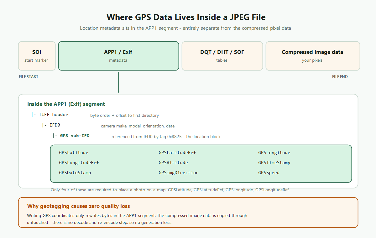
EXIF GPS metadata is what makes Google Photos organize your images on a world map, lets Apple Photos show "Taken near Paris," and allows platforms like Flickr to cluster photos by location. It's also something you can add to any photo after the fact — which is exactly what FreeGeoTagger does.
What Does "EXIF" Stand For?
EXIF stands for Exchangeable Image File Format. It's a standard first defined in 1995 by the Japan Electronic Industries Development Association (JEIDA) and now maintained as part of the JEITA standard. EXIF defines how metadata is stored in JPEG, TIFF, and (with extensions) PNG, WebP, and HEIC files.
EXIF data lives in a dedicated section of the image file binary — separate from the pixel data. This means modifying EXIF metadata, including GPS coordinates, has zero effect on image quality or visual appearance.
What GPS Data Is Stored in an EXIF Block?
The GPS sub-IFD (Image File Directory) within EXIF can store numerous fields. The most commonly used are:
- GPSLatitude — Degrees, minutes, seconds (DMS) or decimal degrees of latitude
- GPSLatitudeRef — North (N) or South (S) hemisphere
- GPSLongitude — Degrees, minutes, seconds of longitude
- GPSLongitudeRef — East (E) or West (W) of the Prime Meridian
- GPSAltitude — Elevation in meters above (or below) sea level
- GPSAltitudeRef — Above (0) or below (1) sea level
- GPSTimestamp / GPSDateStamp — UTC time and date the GPS fix was recorded
- GPSImgDirection — Compass bearing of the camera at time of shot (0–359.99 degrees)
- GPSSpeed — Speed of the GPS receiver at time of capture (useful for dashcams and action cameras)
- GPSAreaInformation — Free-text location name or area
The minimum data needed to place a photo on a map is GPSLatitude, GPSLatitudeRef, GPSLongitude, and GPSLongitudeRef. Everything else is supplementary.
How Are GPS Coordinates Stored in a JPEG?
JPEG files begin with a SOI (Start of Image) marker, followed by a series of APP segments. GPS data lives inside the APP1 segment, which starts with an Exif header followed by a TIFF-format data structure.
Inside that structure, GPS data is stored in a dedicated sub-IFD referenced from IFD0. Each GPS field (like GPSLatitude) is encoded as a RATIONAL type — a pair of 32-bit integers representing a numerator/denominator fraction. For example, a latitude of 40.7128° might be stored as:
- Degrees: 40/1
- Minutes: 42/1
- Seconds: 46/100 (representing 0.768 arc-seconds)
Most software reads and writes decimal degrees (like 40.7128, -74.0060) and handles the DMS conversion internally.
Which Image Formats Support EXIF GPS?
- JPEG (.jpg, .jpeg): Full EXIF GPS support. The universal standard for camera and phone photos.
- TIFF (.tif): Native EXIF support. Used in professional photography and GIS workflows.
- HEIC (.heic): Apple's format for iPhone photos. Stores GPS in a compatible metadata block. Most platforms require conversion to JPEG for broad compatibility.
- WebP (.webp): GPS data stored in an Exif chunk. Support is growing but not universal across all apps.
- PNG (.png): Stores EXIF in an eXIf chunk (uppercase). Less universally supported than JPEG EXIF, but readable by modern tools.
- RAW formats (.dng, .cr2, .nef, .arw): Full EXIF GPS support. GPS is typically written by the camera if location services are active.
FreeGeoTagger supports JPEG, PNG, WebP, and HEIC. You can verify GPS data in any format using our GPS Finder.
How Do Apps Use EXIF GPS Data?
EXIF GPS data is read by virtually every major photo application and many web services:
- Google Photos: Auto-organizes photos by location into Albums and Places. Enables the "Memories on a Map" feature.
- Apple Photos: Shows photos on a map, groups by location in Places view, and shows location in the photo's info panel.
- Adobe Lightroom / Bridge: Displays GPS on a map module, supports filtering by location, and shows coordinates in metadata panels.
- Windows File Explorer: Shows GPS coordinates in the file's Properties > Details tab.
- Google Search: Uses EXIF GPS as a signal for image indexing in Google Images, especially for local queries.
- Flickr / 500px: Place photos on world maps, cluster by location, and enable location-based discovery.
- GIS Software (ArcGIS, QGIS): Reads GPS from photos to plot them on geographic maps for field research and surveys.
How to Add GPS Data to a Photo That Doesn't Have It
Photos taken without location services enabled, scanned prints, screenshots, or images from cameras without GPS chips will have no EXIF GPS data. You can add it retroactively:
- Go to FreeGeoTagger
- Upload your photo (JPG, PNG, WebP, or HEIC)
- Click the map to set the location, search for an address, or enter coordinates
- Download the geotagged version — GPS is now embedded in the EXIF data
The entire process takes under 30 seconds. No account, no software, no upload to any server.
How to Read GPS Data From an Existing Photo
If you want to find out where a geotagged photo was taken — or verify that GPS data was correctly written — use our GPS Finder tool. Upload any photo and it will extract the embedded GPS coordinates and display the location on an interactive map.
EXIF GPS and Privacy
Because EXIF GPS data reveals exact locations, privacy is a legitimate concern. A photo taken at your home, shared publicly, contains your home's GPS coordinates in its EXIF metadata unless stripped.
Most social media platforms (Instagram, Twitter/X, Facebook) automatically strip EXIF GPS data when you upload photos. But email attachments, direct file shares, and some platforms preserve it. Always check EXIF data before sharing photos from sensitive locations.
Summary
EXIF GPS metadata is the technology that makes location-aware photography possible. It's stored as a structured block inside image files, read by virtually every photo app and service, and can be added or removed without any effect on image quality.
Whether you're a photographer organizing a location-based archive, a real estate agent adding GPS to listing photos, or a developer building a location-aware app, understanding EXIF GPS is foundational.
Try FreeGeoTagger to add GPS to your photos, or use the GPS Finder to read GPS from existing images. Both tools are free and work entirely in your browser.
Frequently asked questions
What is EXIF GPS metadata?
EXIF GPS metadata is location information embedded inside a photo file, including latitude, longitude and optionally altitude, timestamp and compass direction. Apps such as Google Photos, Apple Photos and Lightroom read it to place photos on a map.
Where exactly is GPS data stored in a JPEG?
In the APP1 segment, which holds a TIFF-structured block. IFD0 carries camera details and references a GPS sub-IFD by tag 0x8825; the GPS fields live in that sub-directory, entirely separate from the compressed image data.
Which image formats support EXIF GPS?
JPEG and TIFF have full native support. HEIC stores location in a compatible metadata block, WebP uses an Exif chunk, and PNG uses an eXIf chunk. RAW formats such as DNG, CR2, NEF and ARW also support GPS fields.
How are latitude and longitude actually encoded?
As three RATIONAL values — degrees, minutes and seconds — each a pair of 32-bit integers forming a fraction. A separate reference field records the hemisphere (N/S, E/W), because the numeric values themselves are unsigned.
Can I add EXIF GPS data to a photo that has none?
Yes. Any JPEG, PNG, WebP or HEIC file can have GPS fields written into it after the fact. The pixel data is unaffected, so there is no quality cost to adding or correcting coordinates.
Does editing EXIF data change how the photo looks?
No. Metadata and pixel data occupy different parts of the file. A tool that only rewrites the metadata segment leaves the image bytes identical, which is why there is no visible change and no generation loss.